A variety of resources are available to assist subdivisions
and neighborhood groups to develop their own wildfire plan, like
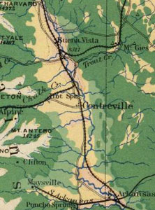
Game Trail and Maysville-North
Fork. Below is a section from
the book “The
Good Neighbor Guidebook for Colorado: Necessary Information
and Good Advice for Living in and Enjoying Today’s Colorado” published
by Big
Earth Publishing. Reprinted by
permission.
Keep in mind that this was
published in 2000, a couple years before Colorado experienced
the Hayman Fire and Congress thought to legislate a solution
with the Healthy Forest Restoration Act.
What Can You and Your Neighbors Do to Reduce Fire Risks?
Develop a Community Fire Protection Plan that includes plans
for the following:
-
Fuel Breaks. These are easily accessible strips of land
of varying width (depending on fuel and terrain) in which fuel
density is reduced, thus improving fire control opportunities and
safety. The forest stand is thinned, and remaining trees
are pruned to remove lower branches that can become ladder fuels. Brush,
heavy ground fuels, snags, and dead trees are disposed of, and
a more open, park-like appearance is created. These should
not be confused with firebreaks, which are large areas in which
the vegetation is completely removed.
-
Defensible space around each building – an area in which
firefighters have room to safely and effectively do their jobs. Essentially
this means thinning trees and eliminating brush close to structures. Pruning
of lower branches is also useful. Stacks of firewood
should not be adjacent to structures.
-
Straightening and widening development
roads and driveways,
if necessary, to accommodate the turning radius of fire trucks. Bridges
should be adequate to support the weight of fire vehicles. Make
sure that all roads, house numbers, and owners’ names
are visible.
-
General forest thinning between structures to reduce the possibility
of crown fires in the tops of trees. Crown fires tend to
spread rapidly and are so intense that suppression actions are
often futile until the terrain or the weather force the fire back
to the ground. General thinning occurs in areas outside
fuel breaks and defensible space.
-
Removal of dead trees (leaving a few for bird habitat). An
abundance of dead or diseased, dying trees is potential fuel
for wildfires.
-
Assessment of wildfire hazard. Work with your local fire-protection
district to assess each homesite’s wildfire hazard. Develop
plans that can be implemented in the event of a wildfire.
-
Banding together with your neighbors, both private and public,
to keep the forests healthy and reduce wildfire risk. These
efforts should help to establish a more fire-resistant ecosystem
that will reduce the danger to the residents and the houses
it contains.
Some of the groups that have already formed to protect large boundaryless
areas are the Pikes Peak Prevention Partners in Douglas, El Paso
and Teller Counties; the Jefferson County Wildfire Committee; the
Boulder County Wildfire Mitigation Group; the Larimer County Wildfire
Council; the Upper Arkansas Wildfire Council in Lake and Chaffee
Counties; the Lookout Mountain Wildfire Committee; and the West
Ranch and Homestead Homeowners Associations.
In partnership with public entities, the community could consider
large-scale activities such as ecosystem restoration, prescribed
burns or localized tree thinning, and support of timber sales on
public lands designed to protect residential areas. Prescribed
burns are planned, human-ignited fires that are controlled in order
to reduce the fuel on the forest floor. Tree thinning and
timber sales can produce difficult-to-dispose-of “slash,” the
limbs and branches remaining after the thinning harvest. This
material may be piled an burned in a safe manner, chipped, hauled
to the landfill, taken to the city mulch pile, or “lopped
and scattered” around the forest floor to rot.
Although such activities can be expensive, the costs may be offset
in part by the sale of forest products. At any rate, the
remaining costs will prove to be many times less than fighting
at fire at the interface between human developments and the forest.
Reprinted by permission. Written by Frank C. Dennis,
Wildfire Hazard Mitigation Coordinator, Colorado State Forest
Service.
“The Good Neighbor Guidebook for Colorado: Necessary
Information and Good Advice for Living in and Enjoying Today’s
Colorado” published by Big
Earth Publishing, 2000.
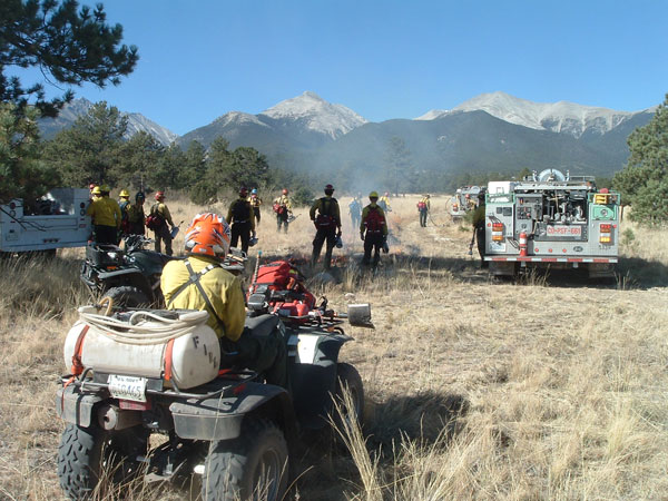
Federal, state and local firefighters prepare to
ignite (and safely control) the Three Mile Prescribed Fire
on U.S. Forest Service land in October, 2007 along the south
border of the Mesa Antero Subdivision in central Chaffee
County.
|