Maysville – North Fork
Community Wildfire Protection Plan
November, 2008
I. Introduction
The Maysville-North Fork Community Wildfire Protection Plan
(CWPP) was initially developed though a series of public meetings
held from May through October, 2004, hosted by the South Arkansas
Landowners’ Association
and the Chaffee County Fire Protection District (CCFPD.) The meetings
used as a template the publication, “Preparing a Community
Wildfire Protection Plan: a Handbook for Wildland/Urban Interface
Communities.” Minor revisions were made at a public meeting
held November 3, 2008.
The Maysville-North Fork CWPP builds upon a foundation of 3
primary documents: the 1995 Maysville-North Fork “pre-attack wildfire
plan”, the 2001 Bureau of Land Management (BLM) Fire Management
Plan for the Royal Gorge Field Office, and the 2001 United States
Forest Service (USFS) Westside Ecosystem Management Project environmental
assessment and decision notice.
A fourth document, the recently adopted Upper Arkansas Valley
Wildfire Plan, will provide a means to remove some sections previously
included in existing community plans, but which should more appropriately
be provided by county-level planning.
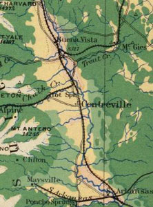
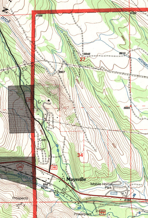
II. Community Base Map
The 1995 Maysville-North Fork plan defined its location by
the legal description: “Portions of Sections 17, 20, 21, 27, 28, 33,
34 T50N R7E and a portion of Section 3 T49N R7E.” In essence
this defines the townsite of Maysville and the North Fork of the
South Arkansas River drainage.
For the purposes of this 2004 Maysville-North Fork plan, the
community base map for private property includes the above and
has been extended west to Fooses Creek (the old townsite of Arbourville)
and the Lost Creek drainage (portions of section 29, 30, 31 and
32 of T50N R7E) and to the east by including the western half
of the southern strip of section 35 T50N R7E and the northwest
quarter of section 2 of T49N R7E (the area south of U.S. Highway
5o and west of the Green Creek drainage.)
The Maysville-North Fork CWPP anticipates 3 additional CWPP
to be adopted in the coming years: Garfield-Monarch (all private
property east of the Continental Divide within T50N R6E and T49N
R6E,) Weldon Creek-Hayden Ranch (portions of sections 25, 26,
27, 35, 36 of T50N R7E) and Cochetopa-Green Creek (portions of
sections 5, 6, 7, 8, 18, 19, 30 of T49N R8E and portions of sections
1, 2, 22, 23 of T49N R7E.)
The Wildland-Urban Interface for the Maysville-North Fork CWPP
is defined as the area bordered to the south by the ridgeline
south of US Highway 50, to the east by the eastern ridge of Weldon
Gulch, and to the north and west by the Colorado Trail.
III. Summary Recommendations
This document is intended to set forth a recommended plan only
and imposes no obligations on the signatories. Specifically,
executing this document in no way obligates Chaffee County to
take any action requiring the commitment of funds in order to
accomplish the Summary Recommendations.
Notwithstanding any other provision of the CWPP to the
contrary, no term or condition of the CWPP shall be construed
or interpreted as a waiver, express or implied, of any of the
immunities, right, benefits, protection, or other provisions
of the Colorado Governmental Immunity Act § 24-20-101,
et seq., C.R.S. (including future amendments) or as an acceptance
by Chaffee County or any responsibility or liability with respect
to the CWPP.
a. Encourage Public Land Fuel Treatments and Planning
#1. Endorse USFS Westside Ecosystem Management Project – Continuation
(and acceleration, where possible) of fuel treatment on USFS
parcels in Lost Creek, North Fork and Weldon Creek drainages.
Recommend that Westside polygons 168, 169, and 170 be treated
with prescribed fire in 2009.
#2. Endorse 2001 BLM Fire Management Plan and designation of
lands adjacent to Maysville – North Fork as “Fire (wild and
prescribed) is desirable but its use is complicated by social, political
or ecological constraints that must be considered.” Recommend
that BLM finish abandoned treatment project in section 27 T50N
R7E as part of a fuel treatment plan to be developed for the
entire Poncha West polygon.
#3. Encourage USFS to update Pike-San Isabel National Forest
fire management plan with input from local residents. Future
updates are likely to include authorization for wildland fire
use (“appropriate
management response to naturally-ignited wildland fires to accomplish
specific resource management objectives in predefined designated
areas”) as part of the revision process to the forest’s
1984 Land and Resource Management Plan.
#4. Encourage Chaffee County to conduct a hazard tree assessment
for public safety and wildfire risk on platted streets and alleys
in Maysville town site.
b. Reduce Structural Ignitability
#1. Improve defensible space and fuel breaks to coincide with
proposed prescribed fire activity on USFS Westside project through
use of Companion funds.
#2. During 2009, conduct comprehensive wildfire risk assessment
with a hazard rating for each lot and house/structure in community,
with assistance of Colorado State Forest Service (CSFS) and CCFPD.
Assessment should inform property owners of particular hazards
and suggest possible actions to reduce risk.
#3. Prior to completion of items #1 and #2, encourage property
owners to implement Firewise recommendations. Sound advice is
found in Jack Cohen’s comment from the “How Homes
Ignite” video/article: “At
a very minimum, you want to make sure there is no fire within
10 feet of your house and then no big flames within 100 feet.”
c. Improve Fire Response Capability
#1. Build CCFPD fire station #5 in Maysville, to house a minimum
of structure pumper, wildland engine, and tender. Recruitment
of volunteer firefighters in response area is critical to this
project.
#2. Develop community water supply plan in conjunction with
CCFPD, CSFS, USFS, and BLM for placement of dry hydrants and
cisterns.
#3. Improve access for firefighting vehicles. With consent
of willing property owners, obtain gated-easement for emergency
access along the east side of North Fork from Highway 50 through
Miller Way, Hanging Tree Drive, and Ponderosa Lodge to USFS land
at intersection of County Road 240 and USFS Road 219. Improve
condition of access roads to both Western Area Power Administration
high voltage power lines that cross North Fork valley to gain
access to east and west ridges.
IV. Authorization
The Healthy Forests Restoration Act of 2003 defines a CWPP
as a plan for an at-risk community that:
“(A) is developed within the context of the collaborative
agreements and the guidance established by the Wildland Fire
Leadership Council and agreed to by the applicable local government,
local fire department, and State agency responsible for forest
management, in consultation with interested parties and the
Federal land management agencies managing land in the vicinity
of the at-risk community;
“(B) identifies and prioritizes areas for hazardous
fuel reduction treatments and recommends the types and methods
of treatment on Federal and non-Federal land that will protect
1 or more at-risk communities and essential infrastructure;
and
“(C) recommends measures to reduce structural ignitability
throughout the at-risk community.”
The Maysville-North Fork CWPP has been developed
by and agreed to by the following entities:
Frank F. Holman, Chairman
Chaffee County Board of Commissioners
date ___________
James Wingert, Fire Chief/Deputy County Fire Warden date
Chaffee
County Fire Protection District
date ___________
Damon Lange, District Forester Colorado State Forest Service
date ___________
Pat Jones, President
South Arkansas Landowners’ Association
date ___________
|